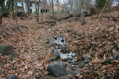
Cut banks--where most of the erosion occurs. They have to be fixed.
Erosion is a problem not so much for residents, as for the lake. A delta has been forming for some years in University Bay, where our stormwater goes. Erosion in the ravine needs to be fixed, in part with a watershed approach.
A watershed approach
Erosion happens in the ravine when there's a big flood. When the creek gets really full, as it may during a cloudburst or spring runoff, rushing water cuts into the banks. Truckloads of soil head for University Bay. These floods are greatly aggravated by pavement all over the neighborhood, so improvements to the neighborhood can reduce the need for desctructive improvements in the ravine.
Slowing the rush of stormwater involves more than just building rain gardens. You need basins to store the runoff from a cloudburst for a couple of days. Nowadays, basins are a requirement for new neighborhoods. But in a developed neighborhood like Sunset Village--where there's no space--what do you do?
The answer is, you get creative! There must be hundreds a little places in the steets, terraces, back yards, and parks, where a tiny landscaping adjustment would cause floodwaters to pool. After a day or so, the water would be gone and no harm done. I have such a spot on my front lawn. No problem!
I'm sure our children would be thrilled to become "deputy stormwater engineers," who would go about the neighborhood during the rain, looking for places to build "stormwater pools." Classes or scout groups could coordinate their efforts, putting the little pools on maps, keeping track of progress. Let's give our kids a reason to turn off the TV and go outside to do something constructive.
"Junior stormwater engineers" receiving encouragement. Hammersley Ave. between Alden and Standish. Note how water pools here naturally.
And inside the ravine...
...the soil is lost from the bank cuts. And the ravine cuts a little deeper every year. Besides these problems with the channel, the slopes of the ravine "slump" or creep downward towards the cannel. So where slopes are steeper, they may need to be shored up with boulders or terraces.
People are going to walk in the ravine, if only to adjust the soaker hoses, pull garlic mustard, or plant some ferns. Their footsteps are going to add to the downhill creep of the soil. So it would be helpful if some very inconspicuous pathways are planned--just flat pieces of limestone. If the city provides these, residents could install them where needed or desired. If we create wet seeps, such stepping stones will become more necessary.
Different zones of the greenway
The public greenway varies in width.
The eastern part is less steep--the stream forms natural pools there. These pools are essential for wildlife.
Downstream, where it's more narrow, it's going to be harder to save the trees, so heroic measures to reduce disturbance are needed there.
At the bottom (western end), some nice trees are growing right in the channel. Here the channel is naturally riprapped, but still probably needs improvement.
 There are lots of trees, so leaves accumulate in the greenway and wash downstream. Can some kind of compact filter be build at the west end of the ravine so leaves can be periodically collected and kept out of the lake?


.jpg)


No comments:
Post a Comment
Please feel free to comment on the article above, or on other watershed issues.