6/24/10

Neighbors to fight for a contractor with good environmental record

On June 24, bids were opened for the Hillcrest-Upland Greenway project.  Two of the four companies had bad environmental records.  The apparent low bidder was the one responsible for killing trees on Spaight Street.

Last year, after the fiasco of trees being killed during reconstruction of Spaight St., citizens vowed that contractors should be held responsible for damage to trees.  In fact, the City's Subcommittee on Construction Site Erosion recommended that a "blacklist" of incompetent contractors be maintained.

The contractor for the Spaight Street mishap was S&L Underground & Trucking of Sauk City.  They are one of the four companies bidding on the Greenway project.  More information here.  As of June 24, S&L Underground & Trucking was the "apparent low bidder" for the Greenway project.  An ideal choice for looking after our valued trees!

Speedway Sand and Gravel of Middleton was another of the four companies bidding on the greenway project.  During the recent reconstruction of Edgewood Ave, Speedway was cited by Contractor Report for numerous violations of good erosion control practices.  City inspection reports also cite violations of the erosion plan.  As of now, they have sent plumes of muddy water four times into Lake Wingra.

You can see a photo of Speedway's Edgewood construction site during the June 21 storm below.

Edgewood Av during June 21, 2010.

It looks as if a mudslide is taking place!  Is this the company you want to work around our valued trees?  If the movement to block irresponsible contractors is to have any teeth, we have to keep Speedway out of the Greenway!

Since our greenway is the sole exit for stormwater from a substantial portion of Sunset Village, it's going to be a disaster if we have a large storm during construction with all the resulting bare earth.  Engineering is "hoping" a big storm won't happen.  And Speedway has already demonstrated it's lack of attention to erosion control.

"Erosion control" was one of the two justifications for this project.  Yet one big storm during construction could produce as much sediment as comes in 10 years from the undisturbed greenway.  So City Engineering has to take extra measures to prevent erosion here, and once necessary measure is excluding contractors with a bad record.

Sunset Village park, looking downstream, after big storm of June 21.
Photo by Tim Kessenich

Sediment basin planned for west end of L Mendota

Muddy runoff into west end of L Mendota after a heavy storm.
Photo: 1960s, UW Engineering


"At a news conference overlooking Lake Mendota, Don Heilman of the Clean Lakes Alliance presented a check for $50,000 to assist with construction of a new sediment basin that will stop more than 41,000 pounds of sediment carried into the lake each year. The new project will treat stormwater runoff from nearly 1,000 acres of residential and commercial land."

"Dane County will contribute a $50,000 Urban Stormwater Grant, the City of Middleton will give $60,000 and the Wisconsin Department of Natural Resources through its Urban Water Quality Grant program will give $40,000 for this important improvement."  More from press release.  June 18, 2010.

Sediment basins are the last line of defense against muddy runoff washing away from bare land, creek banks, and construction sites.  While they mostly stop the trash and mud, they don't stop the flow of nutrients to the lake, so it's best to rigorously enforce construction site rules and other measures upstream.  

6/7/10

Excessive runoff and erosion at Queen of Peace

Two problems--stressing the watershed

Queen of Peace Church and school have the largest parking lot in the Sunset Village and Westmorland Neighborhoods.  There are no structures to infiltrate the rain--like rain gardens or porous pavement.  So when it rains--the roofs, the asphalt, and the eroding soil, together create a torrent of runoff.

There was so much runoff that neighbors downstream complained.  The city responded by adding storm sewer inlets at the corner of Caromar Dr. and Keating Ter.

This excessive runoff, now underground, still creates problems for the city with flooding along University Avenue.  Flooding is one of the reasons behind the massive construction project now taking place there.

There are more problems than just flooding.  Rapid runoff means the groundwater isn't recharged, so springs around Lake Wingra have been drying up.  Deprived of clean water from springs, Lake Wingra becomes more polluted as a greater proportion of its water comes from dirty stormwater. 

As the water table drops, it becomes more costly for the city to pump drinking water.

Curiously, Queen of Peace is in the ground watershed of Lake Wingra, but in the surface watershed of Lake Mendota.  So Queen of Peace sends its floods and its sediment via Willow Creek to University Bay.

At the mouth of Willow Creek, a "delta" of sediment has been forming for many years.

The Eroding Playground

Kids are hard on their toys, and playgrounds are no exception.  It's common to have eroding areas at most schools.  But Queen of Peace is unusual, because the eroding playground washes right onto the parking area, and from there--right to University Bay, quick as a wink.

Soil from the eroding playground washes to the parking lot, then to the Lake.

Midvale Elementary also has some eroding areas, but at Midvale most of the sediment is stopped when the water flows across grass.

Queen of Peace has other eroding areas--along the edge of the parking lot, and along walkways (right).  Just like pavement, bare soil is not good at infiltrating rain water.

I can't help but feel sad, when I see the huge area for parking--so people won't have to walk a few blocks--and then I see the small, eroded areas left for children to play.

Solutions

The total runoff from roofs, parking, walkways, and playground is so massive that--for Queen of Peace to be a good neighbor--planning and work needs to begin.  With a problem developed over many years, starting when people didn't know about the importance of healthy watersheds, Queen of Peace may want to proceed in steps.

A rain garden is simply a depression scooped where water tends to flow.  It helps water sink into the ground, replenishing the water table and taking the strain off gutters and storm sewers.  But it's more than a depression.  Thirsty plants soak up some of the water, while their deep roots act as a conduit deep into the soil. 

For the roofs, tackle one downspout at a time.  If there is one with a big output, the rain garden doesn't have to absorb all of the water from a big storm.  Remember, many storms are small--for them, a relatively small garden may be able to handle everything.  Right now, most of the runoff goes into S. Owen Drive anyway.  So rain gardens can be designed to overflow, in big storms, into the parking lot, or into the street.

There are unused places on the campus suitable for rain gardens.  For example, along Holly Ave, for roof runoff, or at the SW corner of the parking area, behind the backstop.

Walkways can have a strip of rain garden along the low side.
To immediately contain the sediment from the play area, silt socks are the way to go.  They are visible around the edge of the Sequoia Commons construction site.

Different kinds of rain gardens

The key thing in planning, is to go out in a storm, and watch where the water goes--where it flows, and where it pools.

The amount of runoff flowing into the garden determines how much "design" it takes.  Gardens taking substantial runoff may require careful design, both for the plants and the walls that retain the water.  The garden along the east edge of Sequoia Commons is an example.  After a rain, it may contain several feet of water for a few days.

Rain garden at Sequoia Commons--high capacity, with water-loving plants.

But other gardens can be very simple.  All that's needed is removing some soil, enriching the soil in the depression, then planting native woodland or prairie plants, depending the amount of shade.   These gardens can be a fun project for families.

Bob Kowal at 537 Gately Ter. has a wonderful woodland rain garden on his terrace. More. 

Rain gardens on Adams St. are beautifully designed to take street runoff.  More.

Rain gardens--an opportunity for children

Children need a rich and varied environment.  Surrounded as it is by pavement, the play area at Queen of Peace isn't as attractive as it could be.

The University of Wisconsin Arboretum has developed programs for K-12 that involve children in building and studying rain gardens.

There are many people in the neighborhood that can assist Queen of Peace in designing and building rain gardens, along with locating inexpensive plants.  More info.

A commitment?

Could the parish make a commitment to add one substantial rain garden a year, for the next ten years?  Plus many smaller ones that could be a project for groups of families?

The benefits would be many

  • The Church becomes a more responsible civic neighbor.  Helps Madison reach its mandated goal of reducing sediment to the lakes by 40% by 2013.

  • An enriched environment for children

  • More educational opportunities for children

  • Members of the congregation increase their environmental awareness

  • A more beautiful campus

  • A healthier watershed
See a slide show of erosion and runoff problems at Queen of Peace here. When viewing the show, be sure to activate "show info" in the upper right, to see the photo captions.  Move your cursor off-screen to eliminate the thumbnails.  You can also control the speed of the show.  The arrows (lower right) make the show full-screen.

Below: large rain garden fora  parking lot at corner of Struck St. & Watts Rd.

6/6/10

Mud from Edgewood Av reaches lake for 3rd time

On Saturday June 5, I inspected the site just before rain about 4:15 pm, then during moderate rain that lasted for more than an hour.  The pavement of the construction area had been swept, though with imperfect results.  I concentrated my observations on the pipe at the bottom of Edgewood Av, below Vilas Av, because this is "the last line of defense."  There was a large gravel dam on the W side of Edgewood here; on the E side, a silt sock directed runoff into the large pit.

Inside the pit was
  1. A newly laid storm sewer line (apparently not working yet)
  2. A blue pipe bringing stormwater from at least two inlets on Vilas just above the pit, and
  3. A large concrete pipe with a jagged end leading out and directly to Lake Wingra.

The pit, showing water level before rain starts of 6/5.  Pipe on right exits to lake.

When I noticed the pit before rain began, there was a puddle of water in the bottom, with the water's surface several inches below the outlet pipe 3. 

About an hour after it started raining, when I returned, water was cascading in several places into the pit along the sides, and a vigorous stream of muddy water was coming in via blue pipe 2.  The water's surface in the pit was now substantially above the opening to exit pipe 3, and water was flowing towards the lake.  There was now a large plume of muddy water in Lake Wingra, with a vigorous outflow of muddy water from the exit pipe, confirming that this was the destination of the water from the pit.

During the rain, the water in the pit comes up, and exits to the left towards the lake.


I called foreman Todd Timmerman and informed him of the situation about 5:30 pm.  He said that he and Tim Troester had gone over the site on Friday, and that Tim had said that everything was OK.

To me, it appears that the pit was intended to be the last line of defense against runoff, but that the exit pipe had been overlooked.  The pit was taking runoff from the entire E side of the two-block-long slope towards the lake, plus a bit of the W end of Vilas Av.  It was very muddy, because water cascading into the pit was eroding its sides.


Below: Mud in the lake for the third time.


See a slide show of all 6/5 photos here.

6/4/10

Edgewood Avenue construction site is not following sediment plan--evidence

Summary of this posting

Below I present evidence, based on my on-site inspections during two rain storms, that Speedway Sand and Gravel is
  • not following the sediment control plan, and that
  • the plan itself relies too heavily on ineffective measures. 
Since complaints after the first rain of 5/26, we note a number of improvements, but by the rain of 6/2, Speedway had again neglected the most basic measure--street sweeping before the forecast rain.
Because of these shortcomings, a noticeable plume of muddy water has been observed twice in Lake Wingra.

 . . . . . . . . . . . . . . . . . . . . . . . . . . . . . . . . . . . . . . . .
This morning, City Engineering sent an email to persons concerned about the problem of sediment escaping from the Edgewood Av street construction site.  I've reprinted most of this email below, and then I'll follow up with evidence for or against statements in the email.  This evidence consists of photos and observations I made during the two rain storms (5/26 and 6/2).

"City Engineering has required Speedway to complete an erosion control implementation plan which was completed and submitted to WDNR.

 On this project our staff worked with the contractor to implement the plan which included:
  • Construction Entrances/Tracking Pads
  • Construction Entrance Berm
  • Wing dams (along the side of the road where the road has been disturbed)
  • Construction Phasing (keeping as much pavement as possible – currently about ½ the pavement is still in place)
  • Sweeping of the remaining onsite pavement and pavement surrounding the project
  • Inlet filters
  • A sediment trap (at the Vilas end)
  • Limited siltsock/logs
We will be implementing today the use of polymer on all disturbed surfaces and we are investigating the possibility of inlet filters exceeding the WDNR guidance (more restrictive fabric).

I believe both City Engineering and the Contractor have taken erosion control very seriously."

Construction Entrances/Tracking Pads

This refers to a pad of gravel which helps prevent muddy tracks spreading mud outside the construction site.

The gravel pad is visible in the middle-ground.  It is so narrow as to be mostly ineffective--you can see the muddy tracks entering Monroe St.  Photo taken 6/1.

It works by shaking off a bit of mud, plus preventing additional mud from being picked up as the vehicle leaves.  It can only be truly effective if entering delivery vehicles never go beyond the mud-free pad--in other words, if they stay out of the mud at the site.

On my first inspection before rain on 5/26, there was no "tracking pad" at all on the main entrance, at Monroe and Edgewood.  A patch of mud here was causing all trucks to pick up mud as they left the site, spreading it NE on Monroe St.  Soon after this, the pad was installed here--it did correct this one muddy spot, but trucks were still traversing the rest of Edgewood, where the pavement was sometimes muddy and not being swept.

Moreover, there are five other streets (including an alley) entering this site, most of them being used by heavy equipment.  There were NO tracking pads or berms at these entry points.  So, at best, one out of six entry points complied with this part of the plan, and they complied only after the first heavy rain, at least a week after construction started.

Construction Entrance Berm

This refers to a raised area of earth, sufficient to divert runoff from leaving via the construction entrance area.

Of course, if the slope dips back to the construction area, as it does at Monroe and Edgewood, then no berm is necessary.  Where paved streets enter the construction zone but slope away from the zone, no berm is possible without ripping up the street, which would only make matters worse. 

Obviously, to comply with the spirit of this requirement, something else is needed, such as really effective control of sediment in the gutters here.  On the side streets of Madison, Jefferson, Adams, and Vilas, control of sediment leaving the area in the gutters has been mostly limited to sediment traps in the stormwater inlets.  But these traps are ineffective--more below.

Wing dams

These are dams of gravel in the gutters.

This wing dam on Madison St. was ineffective because water bypassed it, going into an unfiltered stormwater inlet beyond.  Photo 5/26.  Click on photos to enlarge.

They slow the rush of stormwater on hills, and they can provide some filtration of the water, depending on the size of the gravel.  On the first rain of 5/26, there were only a few wing dams.  The most important one, on Madison where most water was leaving, was completely ineffective.

After 5/26, a number of wing dams or gravel berms were added.  I would say that most of these ARE effective in slowing the water and filtering large debris, but they cannot be effective in filtering fine particles.

This gravel dam, near the top of Edgewood Av, was more effective, stopping larger particles. 5/26.


Construction Phasing

This is retaining as much pavement as possible – currently about ½ the pavement is still in place.

My observations indicate that, as of today, this is being done and is being effective.

Sweeping of pavement

Sweeping of pavement is done with a Bobcat, using a roller brush and a sort of dustpan--rather like an old fashioned carpet sweeper.

Successful measures:
The pavement was swept clean, afternoon of 6/1. 
Photo also shows construction phasing--retaining as much pavement as possible to minimize mud.  The gravel on left is to protect the terrace, where the curb has been damaged.

Sweeping of pavement, in my estimation, is the simplest and most basic sediment control measure for this type of construction site.  It must be done at the end of the day if there's any chance of rain--it takes, perhaps an hour?  If this is not being done, it would be a good sign that erosion control isn't being taken seriously. 

Sweeping of the remaining onsite pavement had not been done when I inspected before the rain (and during the rain) on 5/26.  When I inspected several times between 5/26 and 6/2, the pavement had been swept. 


But when I inspected during forecast rain on 6/2,
both the pavement and the gutters were quite dirty.
If sweeping did occur that day, it was "undone" by subsequent work.

According to Tim Troester (emails), contractors are supposed to sweep as far beyond the site as muddy tracks can be found.   However, Speedway Sand and Gravel has only swept a short distance down the side streets, no more than 125 feet (I paced it).  When noticeable mud was tracked onto Monroe Street on 5/26, there was no sweeping on Monroe.

In fairness to Speedway, I believe that sweeping more than one block beyond the construction area is impractical, even though significant amounts of sediment can escape this way.  Instead, I believe that the City should require that tires of trucks exiting muddy sites should be cleaned with a high-pressure water spray, as is done in some other parts of the country.

So, sweeping "pavement surrounding the project," as is called for in the plan, is NOT being done.

Inlet filters

These traps, inserted into the inlet of storm sewers, work like giant coffee filters.

They are frequently the last line of defense against sediment leaving a site.  Unfortunately--even if installed correctly--they are mostly ineffective (based on my observations during two rain storms).

Some of these filters were only installed after the first storm, and most of them are installed incorrectly. I believe that most of the sediment escaping the site is via these stormwater inlets, past these failing filters.

Filters work only as long as they do not become overloaded and clogged.  Maintenance is required.  I have seen no evidence that any of these filters have been emptied since construction began.

The most obvious failure of these filters, visible to anyone during rain, is that (because of clogging or improper deployment of the flaps) they allow water to bypass them and flow to the next unfiltered stormwater inlet.

The ineffectiveness of these filters raises an important question.  Even if they are on the plan, even if they are installed correctly at all the necessary spots--still they will not protect the lakes.  The Best Management Practices need to be revised. 

A sediment trap at the Vilas end

This refers to anything that traps and retains sediment at the bottom of the steep hill on Edgewood, near the lake.

As of 6/2, there were three such structures:

Gravel-filled pit at bottom of Edgewood.
No water is leaking past, except via stormwater inlets.  6/2

A gravel dam and gravel-filled pit in the street.  This is being effective--nearly all surface flow from the street directly above is going into this large pit.  However, where this part of the plan fails, is that much dirty water above this pit is going into the stormwater inlets, with their failing filters.  From there, the muddy water goes directly to Lake Wingra, where you can see the muddy plume spreading.

There are two cloth dams on the W side of the bottom of Edgewood Av, on the terrace.

The one further from the street (left) has been well-built and will function in a severe storm.  However, with the storms so far, rain onto the grassy turf above this point is being completely absorbed.   So this barrier is doing nothing to absorb any muddy runoff from the streets.


The second cloth dam, where Edgewood meets the lane along the shore, in my estimation serves no good function.   There is only a trickle of muddy runoff in the gutter here, and this dam does noting to stop it.  6/2.

In summary, the sediment traps at the Vilas end of Edgewood Av aren't fully working, because the muddy water from higher up is bypassing the barriers by entering stormwater inlets.  I believe the gravel pit will work, when the bypass is eliminated.

Limited silt sock/logs

Silt socks are fabric tubes about 18" in diameter, filled with mulch, sand, or other material.

I have watched their use at Sequoia Commons, and note they are quite effective, but only for relatively small flows.  They are able to filter out all but the finest particles.

At a street construction site, the biggest problem is muddy water flowing on the remaining pavement, and from there into stormwater inlets where the filters are ineffective.  The cloth dams can't be used on pavement.  Gravel wing dams don't stop the finer particles.  So it appears that creative use of many silt socks could be used to trap the street runoff, and direct this runoff to more robust treatment basins on terraces.  The silt socks deployed around stormwater inlets could also augment the failing inlet filters.

Given the effectiveness of silt socks, plus the lack of alternatives, we ask: Why does the plan call for "limited" silt socks?

During the rain on 5/26, no silt socks were deployed.

By the rain of 6/2, a silt sock was employed effectively (along with a wing dam) above the Madison-Edgewood intersection.  Effective, except that again the water was doing an end run--this time by flowing into the storm sewer, then upwelling from the storm sewer just beyond the silt sock (at the N corner of Edgewood-Madison).

A second silt sock was deployed on 6/2 at the Edgewood-Jefferson intersection, in the gutter.  But with the entire length of sock stuffed into one tiny gutter, it was evident that this had been done hastily, and that most of the sock was wasted.  With more forethought, parts of this sock could have been profitably deployed in many other gutters.

Improvements between 5/26 and 6/2

After speaking to Foreman Todd Timmerman before the rain on 5/26, and presenting my photo reports to owner of Speedway Tom DeBeck and City inspector Tim Troester, there were a number of improvements:, for which credit is due:
  • Street sweeping was finally begun, including the gutters (but only on-site)
  • Gravel wing dams were added in numerous places
  • A gravel pit and berm was constructed near the lake
  • A silt sock and gravel dam was constructed above the Madison-Edgewood intersection, where much runoff exits the site.  A second silt sock was stuffed in one gutter.
  • A second inlet filter was added further down Madison (both sides). There were changes to and around some of the inlet filters.
  • A gravel pad was added at the Monroe entrance to Edgewood.
  • A second cloth dam was added to the terrace at the bottom of Edgewood near the lake (though it doesn't seem to do much).
The email above indicates additional improvements are underway. Construction today was halted after a third rain, and the foreman was onsite, planning improvements.

Are fines called for?

I would like to hope that these improvements mean we should be patient--that Speedway means to comply.
Yet two facts contradict optimism:
  • Why did Speedway fail to begin most parts of the required plan--until after complaints, and after the first storm?
  • Why did Speedway fail to sweep--before the second storm?  Sweeping is the most basic (and simple) aspect of sediment control. It should be taken as an "indicator" of a street contractor's intentions to comply. And if they are unable to comply, then an indicator of their competence.
The photos speak volumes. Speedway has not been in compliance with their sediment control plan. They started late, and implemented some parts poorly or not at all. The plan itself relied on ineffective measures. The only unqualified success was the construction phasing.

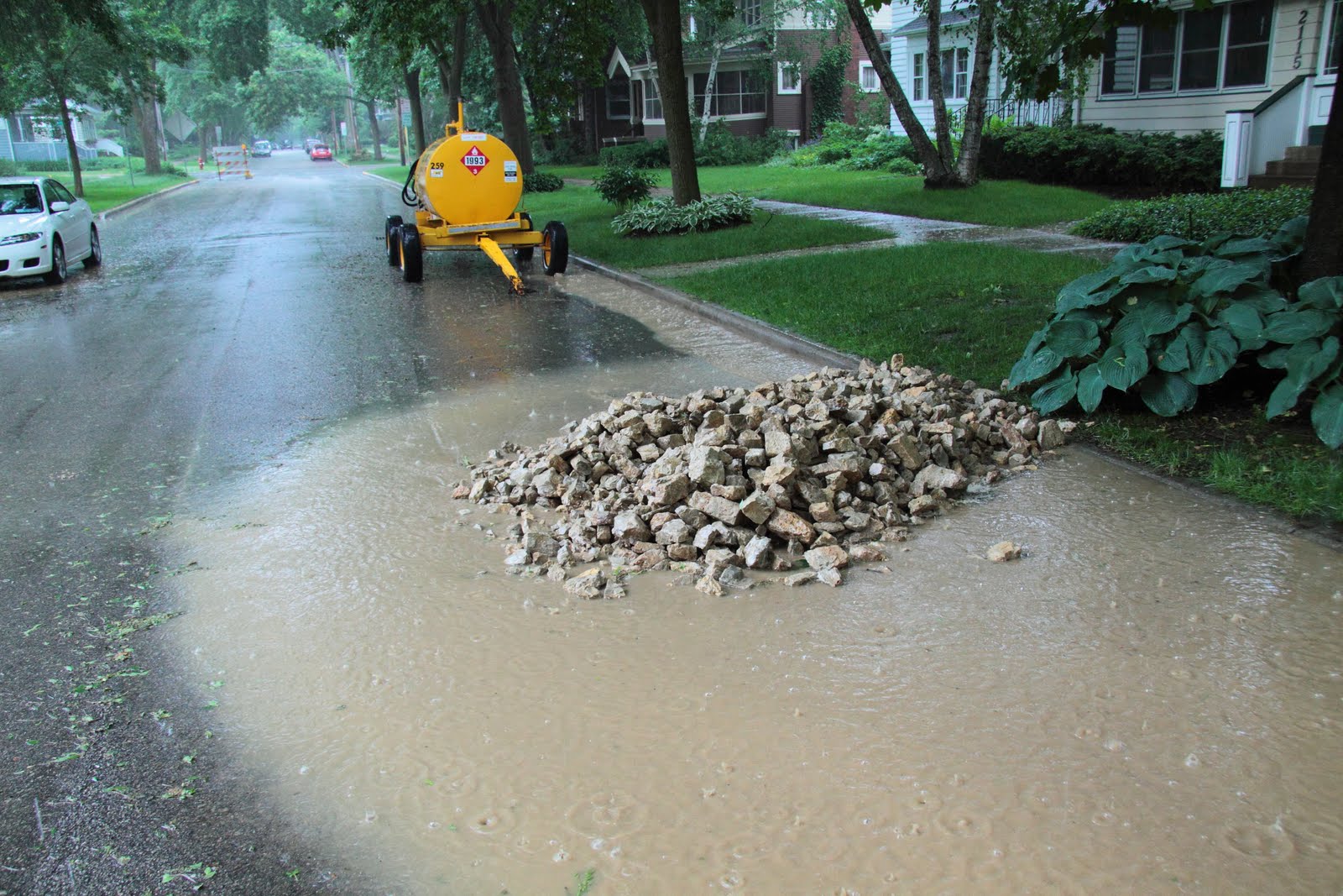
The bottom line: Twice, sediment escaped to Lake Wingra. Photo:6/2

Options going forward
  • Fine Speedway for non-compliance with plan, which has clearly occurred.
  • Place Speedway on a list of "unreliable" contractors, as recommended by the Subcommittee on Construction Site Erosion.
  • Amend the plan to include more effective options, such as those mentioned above in Engineering's email, or use the terraces to filter or infiltrate runoff.
Links to additional photos
Edgewood Av Construction before the rain, 5/26/10
Edgewood Av Construction during the rain, 5/26/10
Edgewood Av Erosion Control Improvements, 6/1/10
Edgewood Av street construction during rain, 6/2/10
Edgewood Av Erosion Control Improvements before rain, 6/5/10
All photos on inlet filters from 5/26 and 6/2.

6/3/10

Using terraces to help control runoff from street construction sites

Construction sites have always been a significant source of sediment to our lakes--plus 19% of the phosphorous contribution. 

Street construction sites present a special challenge, because spaces are tight, surrounded by buildings.  Streets have to be kept open for heavy equipment and emergency vehicles.

During construction, the pavement gets covered with mud... and then it's hard to prevent muddy runoff from leaving the site.

Barriers are used to stop or filter runoff--like gravel dams, sock dams, cloth barriers, and filters over storm sewer inlets. But based on my observations of construction sites during storms, I believe that some of these traditional methods are not very effective.

A much better way to deal with runoff is to use settling basins. These both remove the sediment and recharge the water table. The only way they can fail--is to be too small or to overflow. So basins need to be large, and usually there's no room on the construction site.

Recently at the Edgewood Avenue construction site, I noticed muddy water exiting the site, then flowing a long way in the gutter down the street. I realized that you can use the gutters to export muddy water, and treat it somewhere else, where it's more convenient.

Terraces can be used to store, infiltrate, or filter runoff leaving the construction site along a gutter.

 How the idea could work for a construction site:
  1. Survey the site, to see which way runoff would flow out.
  2. Locate suitable terraces, within several blocks along the flow path, and gain the cooperation of residents, if possible.
  3. Before the construction site begins, dig out the entire terraces at selected sites to below street level. If the curb or sidewalks need to be shored up, add gravel.
  4. Cut two notches in the curb to allow entry (and exit, when full) of water into the terrace depressions.
  5. Repeat with enough of these terrace basins to handle most of the expected runoff.
  6. Block any storm sewer entrances along the runoff flow.
  7. When the construction project is finished, fill the terrace depressions back to the desired depth, and plant with native plants (or whatever the homeowner desires). Organic street sweepings could be used to enrich the soil.
When runoff is found to be escaping from a construction site, a terrace basin could be built in one day to correct the problem. The Fire Department doesn't require a City Council resolution to go into a home and put out a fire. The terraces are City property.

Advantages for construction sites:
  • Relatively inexpensive
  • Overcomes space or other limitations at the construction site
  • More reliable and more complete (100%) filtration of runoff
  • Recharges groundwater
  • Improves the watershed and neighborhood permanently by leaving a garden
  • Flexible and fast--more terrace basins can be built when more capacity is needed.
Disadvantages
  • Can only be used where slopes and terrain are suitable
  • Some residents may object
Looking down a steep hill towards Lake Wingra:
This terrace along Edgewood Av could be used to treat the muddy runoff from the gutter.

Below: Plan for filtration of gutter runoff on a sloping terrace.
More info about the silt socks used in the plan below.

Advance planning

The terrace pictured above is an example of the need for a long-term view.  Looking ahead, this street sloping steeply to the lake will always present a runoff problem.  A large rain garden located here would be an ideal way to slow and infiltrate water from the gutter.

Likewise, the terrace presents an opportunity to treat runoff during the street construction project.

To obvious conclusion is--a rain garden that could handle runoff from the construction project should have been built here a year before street construction began.  By having the city handle the rain garden construction, this important detail wouldn't be subject to the whims and omissions of a contractor.  In most cases, the schedule for construction projects is known well in advance, so why can't the necessary rain gardens be built in advance?
. . . . . . . . . . . . . . . . . . . . . . . . . . . . . . . . . . . . .

Plan for filtering runoff on a barely sloping terrace.
Water exiting at the bottom simply flows to the next open storm sewer.
When construction is over, pit is modified to become a rain garden.


6/2/10

Will Sunset Village Ceek still run on the surface?

In discussions after a Cap Times article on the greenway, one person questioned whether the stream would run on the surface again.  This started some email discussions between resident David Newby and City officials about the issue of surface flow.

A little hydrology

Normally, you see water flowing in a creek because the stream is in balance with the goundwater.   The stream usually runs in a valley, biting down to reach the level of the ground water.   You might say the stream is just the visible part of the groundwater.

If there's an excess of groundwater, or the groundwater level is higher than the stream, groundwater will flow into the stream, augmenting it.  If the groundwater level is lower than the stream, water from the stream flows into the ground, trying to raise the level of the groundwater. 

In some cases, something might cause the groundwater level to recede from the level of the stream.  There might be a large well nearby, or something else drawing away groundwater.  If this lowered level persists for some distance, of if the stream is only a trickle, then the dry ground will suck up all the water in the stream, and the stream will disappear.  It's not uncommon in the mountains or deserts to see a stream appear and disappear, depending on the level of the groundwater.

Sunset Village Creek originates in a shallow basin bounded roughly by Mineral Pt., Larkin, Hillcrest, and S.Owen.  Because it's a shallow basin, the groundwater is close to the surface, and the creek often runs on the surface through the park.

But in the Hillcrest-Upland Greenway, the water table apparently withdraws from the level of the creek, and so the creek dries up in the lower part of the greenway.  Usually, however, there are a few pools in the upper portion, even some time after a rain.   The water table is evidently on the surface or close to it here.  That is why I proposed some pools for the upper greenway in the plan.  I simply wanted to capitalize on the existing situation--for the sake of wildlife.

Pools at the upper end of the greenway--a place for wildlife to drink.

It's worthwhile asking: "Why does the water table withdraw from the surface in the lower greenway,causing the stream to dry up?"
  • There's a steep slope to the west here, and generally speaking, water tables often withdraw from the surface in hills.
  • More likely, the groundwater here is leaking into the sanitary sewer pipes.  We heard there were a number of leaks, but we don't smell sewage on the surface.  This suggests that groundwater is leaking into the sewer, rather than sewage leaking out.
  • In a similar vein, the groundwater might simply be flowing in the trench through gravel alongside the old pipe.  In other words, the stream is flowing underground, following the pipe.
Riprap (stone rubble) and surface flow

Riprap is death for a stream.  Dumping riprap will usually raise the surface, separating the stream from the groundwater.  In addition, the riprap creates a lot of little pockets between rocks, through which the water flows.  So, if it's only a trickle, water will flow through these spaces at the bottom of the riprap layer, out of sight.  You will only see water on the top of the riprap if there's enough water to fill all those spaces, or if sediment eventually fills all those spaces after five or ten years.  Even if sediment fills the spaces, water won't be visible if the water table is still below the top of the (elevated) riprap.

If you want to see how water becomes invisible after riprap is applied, just look at the riprap along the SW Bike Trail, just below the Glenway Golf Course.

Some residents are concerned about mosquitoes.  Of course, mosquitoes and other aquatic insects are the base of the food chain, attracting other wildlife.  But riprap can create a mosquito problem because the little pools of water under the riprap will be out of sight.  Visible pools can be treated with a larvacide if necessary--invisible pools can't be treated.

In summary, I agree mostly with Lisa Coleman's email comments about the issue.  Water will be visible in the channel during times of high flow, such as spring thaw or during a storm.  At other times, you and the wildlife can kiss the water goodbye.

Stability is important for nature 

Wildlife need to be able to count on water.  If the water is visible sometimes, but invisible most of the time, that's bad for wildlife.  This alternation of floods with dry channel makes for a very sick stream.

The water in the upper part of the greenway will disappear because the channel will be raised, the water will flow between the cavities in the riprap, and because water will also sink down to the gravel packed around the new sewer pipe.   Here the pipe and the gravel will act like a "French drain."

My friend Liz McBride had standing water problems near her back door.  She had French drain (a pit filled with gravel) installed there, and has never seen the water again.

There has been talk about placing an impervious "clay cap" over the new sewer trench, under the riprap, to help keep water on the surface.  Given the other reasons for water going underground, I don't think a clay cap would make any difference.  Only paving the bottom of the channel, as an alternative to riprap, would work--as Tim Kessenich has demonstrated in his yard.

The stream in Tim's yard.
Paving streambed as he did, or improving the watershed, are the only ways to keep the stream on the surface.

Meanwhile, back to the watershed

Once upon a time, our little basin of Sunset Village was perhaps a wet sedge meadow, bordered by some low, oak-covered hills.   A little stream trickled out of the basin--serving as home for green herons, phoebes, wood thrushes, and other birds and animals that came to drink.

The little stream trickled down a steeper slope, then joined a larger creek flowing through wetlands on present-day Midvale Blvd, Lucia Crest Park, and University Avenue.  Eventually it reached large wetlands bordering lake Mendota, now the site of playing fields and parking lots.  Old sand dunes from glacial times, covered in 1850 with oak savanna (the vet hospital), overlooked these expansive wetlands.  Fast-growing wetland plants sucked any nutrients or mud from the water that had escaped from the wet meadows of Sunset Village. 

In those days, Lake Mendota was almost crystal clear, perhaps with a slight color of tea.  The Winnebago would drink from it as they waded along its shore.  Harry Whitehorse, who lives near Madison and grew up on her waterways, can almost remember those days.

But in the 1950s, much of Sunset Village was roofed or paved; and two churches paved large parking lots.  Resulting floodwaters then rushed down the ravine, eroding it.  With unruly runoff racing to University Avenue, there were no waters to recharge the soil of the basin.  So the water table dropped, and the little stream mostly dried up.

Having lost the battle to save the last pools of this little stream in the greenwa--this little memory of the past--we must refocus on restoring the watershed of Sunset Village to health.  This is our only hope to keep a little water on the surface, where children can learn of its charms. 

There will be many benefits to increasing infiltration of rainwater in our neighborhood:
  • More gardens and interesting green space.  The city would help pay for them.
  • More wildlife
  • More diverse play spaces for children
  • Better flow of the stream in the park
  • Reduced flooding on University Avenue
  • Healthy lakes (surface flow goes to Mendota; groundwater flow to springs around Wingra)
  • Lowered costs for pumping drinking water
  • Save on your water bill (the stormwater part)
  • And finally, a more verdant greenway (because there's more groundwater for the plants)
We lost this verdant little oasis--the greenway--because people retreated to their yards, behind fences, and said "Let the city take care of it.  The engineers know what to do." 

We can regain some of what we've lost by coming together, joining in community with neighbors, to restore the land.  We can do things to help in our own yards, like composting, rain barrels and rain gardens.  But real progress will take community action, neighbors working with neighbors, taking responsibililty for the "liveability" of their neighborhood.
Neighbors working togethe
to create rain gardens on Adams Street. 
Photo from city website.  More
.........................................................................

Question:  Should we leave out the clay cap, to give the stream a chance to recharge the groundwater?

It depends on your goal--whether you want the stream to recharge groundwater or whether you want it on the surface for people and wildlife.   Since the great bulk of the water just rushes through the greenway during floods, it's not going to do much work for recharging groundwater.  The clay cap won't make any difference.  We should concentrate on recharging groundwater further upstream, with downspout rain gardens, terrace rain gardens, and porous pavement.   If the decision to use riprap hadn't already been made, I would vote to have some open pools in the greenway for people and wildlife.

Question: What makes you an "expert" on groundwater and stormwater?

I spent my youth playing around lakes and streams.  When I built sand castles, I gave them waterworks--the moat really worked.  I explored a stream in my neighborhood.   I still spend a lot of time out with my camera, exploring streams and pipes.   By burying streams, and destroying our watersheds, I'm afraid today's children will be deprived of these pleasures, and will be denied these ways to find out how the world works.

A checklist for evaluating runoff from construction sites

Controlling runoff of sediment from street construction is difficult, because the streets themselves are the runoff channel, and the streets must remain open for construction and emergency vehicles. 

Nevertheless, a checklist can help focus efforts on the most important runoff channels, and on the most effective methods.

No complicated task can ever be successful without feedback.  This means evaluating the outcome from each rain storm, and adjusting the checklist--along with the solutions employed.

This checklist is offered as a first attempt to judge the effectiveness of sediment control at the Edgewood Ave construction site.  Since the project will continue until August, there will be numerous rainstorms, offering an opportunity to observe, adjust and tune sediment control measures.

                                           .............Methods............
Method's effectiveness------->1       2        2        2         6
Runoff channels          Vol  filter  fence  sock  grdam  basin
Madison St                     4      1       x        0        2         0
Jefferson St                   0      1       x        0        2         0
Adams St                       1      1       x        0        2         0
Vilas St                          1      1       x        0        2         0
SWend Edgew                1      1       x        0        3         0
NW Terrace Edgew         0      x      3,0      x        x         0

Explanation of table

"Vol" = an estimate of the relative volume of runoff from various streets or terraces.  The "4" next to Madison Street means roughly 4 times the runoff goes down this street, compared to any other exit path.  A "0"was given to runoff from the NW terrace of Edgewood Av, since water is absorbed by the turf and runoff will occur here only during a severe, prolonged strorm. 

"Filter" = the cloth filter bags placed into the stormwater inlets.  I do not consider these to be very effective.

"Fence" = a cloth fence.  These are installed only over soil, so an "x" appears for the streets--the fence can be used only on the terrace.  Can be very effective.  There are two fences now, hence two numbers.  The newer fence seems ineffective.

"Sock" = a silt sock.  Can be very effective for small flows.

"Grdam"=gravel dam.  The effectiveness of these can vary widely, depending on amount of gravel, gravel size, and whether there is pavement or soil below.

"Basin"=infiltration basin, retention basin, large rain garden, or terrace rain garden.  These are the most effective by far, because they retain all sediment, recharge groundwater, and filter pollutants.

I did not include "street sweeping" in the table to keep it small, but obviously, this is the most basic and important technique.  We will assume sweeping is employed to the max.

 Observed effectiveness ratings (during a storm) for each cell in the table:
x=this method is not possible here.
0=This method was not deployed here, or was completely ineffective.
1=Poor effectiveness
2=Moderate effectiveness
3=Very effective

My "observed effectiveness" ratings in the above table are guestimates.  I did observe the site during the heavy storm of 5/26, but changes to the perimeter controls have been made since then.

The next step--a spreadsheet for "weighted effectiveness"

The above "raw" table, as is, can be useful as an overview of progress. 

The table can be made still more effective if it is "weigthted" for both the relative volume of flow (left column), and the "relative effectiveness" of the method (top row).  In other words, you would multiply the score in the above table by both the relative volume and the relative effectiveness.   Hence, by this reasoning, a retention basin on Madison Street would be by far the most effective method you could employ for the entire project. 

The practicality of such a basin in another matter--but I've made a proposal here.  Another possibility would be to use the low ground on the nearby Edgewood College lawn.

The effectiveness of a basin would depend on its size.  If large enough, it would have an effectiveness rating of 3.  This would give a retention basin serving Madison St. a score of  3 (observed effectiveness) x 4 (relative flow) x 6 (method effectiveness).

A weighted table would provide feedback for everyone involved to see the effectiveness of their efforts.

Conclusions from spreadsheet, as of 6/2/10
  • More efforts need to be directed towards Madison Street, the principal runoff pathway.  
  • Basins would greatly improve the score for this project. 

Gravel dam on Madison, near corner with Edgewood, where the most runoff exits the site.  Gravel dams vary in effectiveness--this one was mostly ineffective.  5/26/10.  More photos


Filter on storm sewer inlet, Madison & Edgewood.  I consider these to be of low effectiveness, since they vary in how the flaps are arranged, and many of them (like this one) block any inflow because of flap arrangement or clogging. They do not recharge the water table, and they cannot filter fine particles or dissolved material.  5/26/10


Cloth dams can be very effective, but they must be built on soil. This one near Lake Wingra was left from another project.  It sagged and nearly failed here, illustrating that these must be maintained.


These silt socks, shown at Sequoia Commons, can be very effective, but only for small flows.   They might be used to dam a street, if drawn across at the end of the work day).  As of 6/1, they had not been deployed at Edgewood Av.